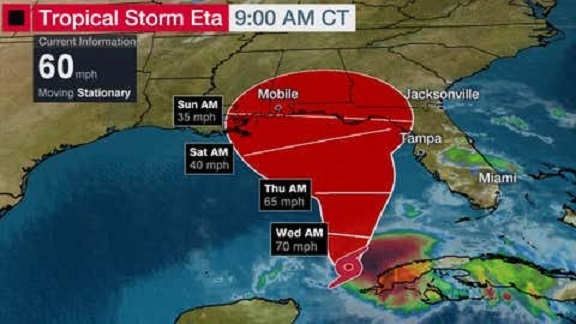
Tropical Storm Eta Moving Slowly and May Linger in Gulf the Rest of the Week

Eta is stalled right now, but it should begin to move slowly northward through the Gulf of Mexico later Tuesday into Wednesday. Its possible Eta briefly gains some additional strength through Wednesday. Eta could simply move northward slowly toward the northern Gulf Coast late this week or this weekend ahead of a frontal system arriving from the mainland. That could be anywhere from northwest Florida to southeast Louisiana.
However, a number of forecast models suggest that high pressure may build back in place to the north of Eta, ending its northward drift and either trapping it or moving it westward for a time. It's too early to know what, if any, impacts Eta might bring to parts of the northern and western Gulf Coast later this week. It's possible some areas could see rainfall and/or gusty winds.
In the meantime, Eta could produce an additional 1 to 2 inches of rainfall over South Florida through Tuesday night. Other parts of the Florida Peninsula could see bands of rain and gusty winds persisting through Thursday. Flash flooding is possible in areas where bands of rain track over the same area for a period of time. Tropical moisture associated with Eta will also help to enhance rainfall along a cold front moving through the South and East Wednesday into Thursday.
We recognize the severe impact that current conditions are having on our customers and we are committed to restoring service levels as quickly as possible. As a result of these weather issues, the ALG Client Service Team will send daily updates as we monitor the progress and track job level impact.