Eta Strengthens Into a Hurricane off Southwest Coast of Florida
Eta is expected to bring heavy rainfall, gusty winds, storm surge and isolated tornadoes to portions of the Florida Peninsula. A tropical storm warning and hurricane watch are now in effect for a portion of Florida's western Gulf Coast.
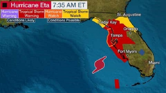
Eta is centered about 130 miles west-southwest of Fort Myers, Florida, and is moving to the north-northeast. Maximum sustained winds have increased to 75 mph, making Eta a Category 1 hurricane. A tropical storm warning has been issued for a part of the west coast of Florida from Bonita Beach north to the Suwannee River, including Tampa-St. Petersburg, Sarasota and Fort Myers, as well as for the Dry Tortugas west of the lower Florida Keys. Tropical storm conditions (39 to 73 mph winds) are expected along this portion of Florida's western coast later Wednesday into Thursday. There is also a hurricane watch in effect along Florida's western coast from Anna Marie Island to Yankeetown. This means hurricane conditions are possible in a part of this area by early Thursday. Eta is forecast to produce a relatively modest, but still hazardous, storm surge along the west coast of Florida from the Everglades to the east side of Apalachee Bay.
We recognize the severe impact that current conditions are having on our customers and we are committed to restoring service levels as quickly as possible. As a result of these weather issues, the ALG Client Service Team will send daily updates as we monitor the progress and track job level impact.