Major nor’easter clobbering Eastern Seaboard with heavy rain and wind.
States of emergency were in place in New York and New Jersey as officials were on high alert for the storm’s impacts, which forecasters said could rival those of Ida and Henri.
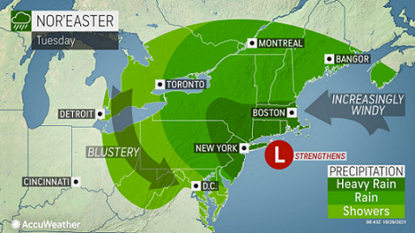
Flash flood watches and warnings were in place on Tuesday as a major storm system continued to crawl up the Atlantic coast where it was unleashing drenching rain along the Interstate 95 corridor and pounding coastal areas with rough surf and high winds. AccuWeather forecasters say it’s just the first of multiple storms that will take aim at the Northeast during the final week of October.
Severe flash flooding was already ongoing Tuesday morning in parts of New Jersey as the storm, the first nor'easter of the season, continued to strengthen. Some parts of the state reported more than 4 inches of rainfall over a 24-hour period early Tuesday.
The storm has been categorized as a nor'easter since it will be spreading northeasterly winds along the coast and is the first such storm of the season to impact the region. The storm is forecast to complete a counterclockwise loop near the Northeast coast into Wednesday night, which will prolong adverse conditions in New England and Long Island, New York.
Forecasters said the storm had undergone a period of rapid intensification overnight, but by late Monday morning still had not met the benchmark for bombogenesis, which is when the central pressure of a storm drops by 0.71 of an inch of mercury (24 millibars) or more over a 24-hour period to become what is known as a bomb cyclone. Two similar storms developed in the northern Pacific and slammed into the western U.S. late last week and over the weekend.
The rainfall that pushed into New York City late Monday evening is expected to last into Wednesday morning, the National Weather Service issued a flash flood watch for New York City, starting at 8 p.m. Monday and lasting through 5 p.m. Tuesday to account for the impacts by the heaviest rounds of rainfall. The New York City Emergency Management also issued a travel advisory for Monday evening through Tuesday afternoon.
New York Gov. Kathy Hochul declared a state of emergency for the Capital Region, Long Island, New York City, Mid-Hudson and Southern Tier regions late Monday evening. Likewise, New Jersey Gov. Phil Murphy also declared a state of emergency in preparation for the storm's impacts and urged residents to stay off the roads, stay vigilant and follow safety protocols.
The heaviest rainfall amounts are expected in northern New Jersey, northeast Pennsylvania, southern New York, Massachusetts, Connecticut and Rhode Island as a widespread 4-8 inches is predicted across these states.
Areas that experience particularly intense and long-lasting rainfall will pick up totals near the high end of this range, with an AccuWeather Local StormMax™ of 10 inches (250 mm) from Monday night to Wednesday.
Elsewhere, rainfall totals of 2-4 inches are forecast from far southern Maine through eastern New York and a large portion of New Jersey. Localized flooding cannot be ruled out, but flooding incidents will be less widespread. Travel delays could still become a problem where water ponds on roadways.
We recognize the severe impact that current conditions are having on our customers and we are committed to restoring service levels as quickly as possible. As a result of these weather issues, the ALG Client Service Team will send daily updates as we monitor the progress and track job level impact.