Winter Storm Could Snarl Travel from the South to the Mid-Atlantic and Northeast
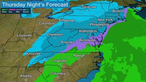
A winter storm spreading snow and some ice from the mid-South to the mid-Atlantic and Northeast will likely create travel headaches across those regions into Friday.
This latest system - named Winter Storm Garrett by The Weather Channel - is following on the heels of Sunday and Monday's snowstorm, which dumped over a foot of snow in parts of Virginia, Maryland, Delaware and southern New Jersey, and left travelers stranded on an icy stretch of Interstate 95 near Fredericksburg, Virginia, into Tuesday. That storm also dumped as much as 6 inches of snow over much of Middle and East Tennessee into northern Alabama just after record warmth rang in the New Year.
Garrett is spreading snow and a narrow zone of freezing rain and sleet as far east as the mid-South region right now. Freezing rain coated elevated surfaces in western Tennessee early Thursday, including the Memphis metro area. Snow fell at the rate of 2 inches per hour Thursday morning in Jackson, Tennessee, leaving stretches of Interstate 40 snow-covered and hazardous.
Snow then moved into the Nashville metro area at the tail end of the morning rush hour, as The Weather Channel meteorologist Jim Cantore saw firsthand. Nashville International Airport reported snow fell at the rate of 1 inch per hour Thursday morning. A number of winter storm warnings, winter weather advisories and winter storm watches have been issued by the National Weather Service from the mid-South to the Appalachians and New England for Garrett.
We recognize the severe impact that current conditions are having on our customers and we are committed to restoring service levels as quickly as possible. As a result of these weather issues, the ALG Client Service Team will send daily updates as we monitor the progress and track job level impact.