Winter Storm Izzy to Spread Mess of Snow, Ice from Midwest into South and East into MLK Weekend
A major winter storm tracking into the Midwest right now will sweep across parts of the South and East through the Martin Luther King Jr. holiday weekend with a mess of snow, ice and wind. Named Winter Storm Izzy by The Weather Channel, this sprawling storm will produce major travel headaches from North Dakota down to northern Georgia and up to Maine. Izzy is currently producing snowfall in the Northern Plains and upper Midwest.
In general, the worst weather is expected in areas with winter storm watches and warnings. These areas are where driving will be dangerous.
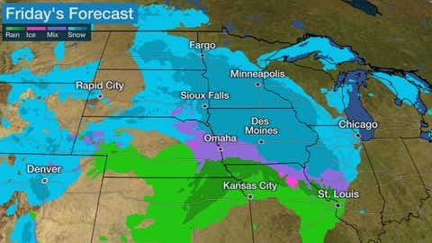
Friday
Snow will continue to spread southeastward during the day from the Northern Plains into parts of Minnesota, Iowa and eastern Nebraska. Snow could be heavy in some of those areas. Friday night, snow should eventually taper off in North Dakota, South Dakota and much of Minnesota, but will continue - heavy in spots - over eastern Nebraska, Iowa, northern Missouri, northeast Kansas and western Illinois. Rain changing to snow could spread into southern Missouri, southeast Kansas and northeast Oklahoma.
Saturday
Snow will continue to sink southward during the day through parts of southern Missouri, southern Illinois, western Kentucky, eastern Kansas, eastern Oklahoma and northern Arkansas. In some of these areas, snow may become heavy.
Saturday night, a mix of snow, sleet and freezing rain is expected to develop from parts of northeast Georgia into northern South Carolina, North Carolina and southwestern Virginia. Snow could be heavy in the southern Appalachians. Meanwhile, snow will continue Saturday night from Arkansas and southern Missouri into Kentucky and parts of Tennessee. Some sleet or freezing rain could mix in at times over parts of Kentucky and Tennessee.
Sunday
From this point on, there is still some lingering uncertainty in the forecast, dependent on the exact track of low pressure and the extent of cold air.
For now, it appears snow is likely Sunday from Kentucky and Tennessee across the Appalachians from the north Georgia mountains to West Virginia and southwestern Virginia. In some of these areas, snow may be heavy at times. Some snow may also spread into the upper Ohio Valley and linger in parts of northern Mississippi and northern Alabama.
Sleet and freezing rain is increasingly likely from northern Georgia to northern South Carolina and much of North Carolina into Virginia. Exactly where the corridor of the most significant icing sets up is still uncertain.
Areas closer to the coastal Carolinas and southeastern Virginia might see more rain than wintry precipitation. Snow, possibly mixed with sleet and freezing rain, will also spread into the Mid-Atlantic States Sunday, then into much of the rest of the Northeast Sunday night. This snow will become heavy in some areas.
Closer to the Northeast seaboard, precipitation may change over to rain Sunday into Sunday night. This includes the Interstate 95 corridor from Washington, D.C. to Philadelphia and New York City, where a period of snowfall could transition to rain.
Strong winds are possible Sunday and Sunday night over parts of the Southeast, spreading into the mid-Atlantic and Northeast as low pressure strengthens with the storm.
We recognize the severe impact that current conditions are having on our customers and we are committed to restoring service levels as quickly as possible. As a result of these weather issues, the ALG Client Service Team will send daily updates as we monitor the progress and track job level impact.