Hurricane Milton to Make Landfall in Florida Tonight with Life-Threatening Storm Surge, Winds, Flooding

Hurricane Milton will make landfall in Florida tonight into early Thursday where it poses a major threat to life and property as it hammers the state with destructive storm surge, devastating wind damage, potentially catastrophic flooding rainfall and several tornadoes.
"The track of Hurricane Milton continues to be a worst-case scenario for the Tampa Bay region southward to Charlotte", the National Weather Service in Tampa Bay said in a briefing Wednesday morning. This is a life-threatening situation, and all evacuations and storm preparations should be rushed to completion this morning.
Milton is a Category 4 hurricane packing winds up to 155 mph as of 8 a.m. EDT. It is centered 250 miles southwest of Tampa and is tracking to the northeast at 16 mph. Rainfall from the hurricane is spreading across parts of the state well in advance of landfall. A tornado watch is in effect for the southern half of the Florida Peninsula until 9 p.m. EDT, including Miami, Tampa Bay and Fort Myers.
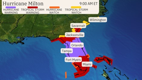
Hurricane warnings cover much of central Florida from the Gulf side to the Atlantic side, including the Tampa Bay area, Fort Myers, Orlando, Cape Canaveral and Daytona Beach. This means hurricane (sustained winds of 74 mph or higher) conditions are expected within the warning area from Wednesday evening into early Thursday.
Various tropical storm watches and warnings cover other parts of Florida, southeast Georgia, southeast South Carolina and southern North Carolina. This means a life-threatening water rise from storm surge is expected in these areas late Wednesday into Thursday.
We recognize the severe impact that current conditions are having on our customers, and we are committed to restoring service levels as quickly as possible. As a result of these weather issues, the ALG Client Service Team will send daily updates as we monitor the progress and track job level impact.