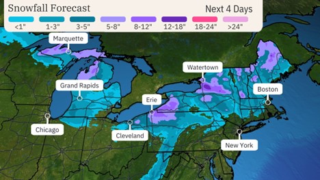
More Lake-Effect Snow to Blanket Hard-Hit Great Lakes Snowbelts

Various winter weather alerts have been issued by the National Weather Service in the Great Lakes snowbelts for both ongoing snow and the next round set to arrive Wednesday through Thursday.
A powerful cold front meteorologists call an "Alberta Clipper" will plunge south out of Canada into the Midwest Wednesday, then into the Northeast Wednesday night into early Thursday.
Given the strength of this cold front and accompanying jet stream, brief bursts of snow called snow squalls may accompany the cold front as it slices through the Great Lakes Wednesday and Wednesday night.
Together with strong winds both ahead of and behind the front, these snow squalls may lead to sudden, dangerous reductions in visibility and quick accumulations on dry roads. Keep this in mind even if driving in areas outside the Great Lakes snowbelts Wednesday and Wednesday night.
Those cold winds pouring over the still warmer Great Lakes will regenerate lake snowbands Wednesday into Thursday before they fizzle from west to east by Friday.
We recognize the severe impact that current conditions are having on our customers, and we are committed to restoring service levels as quickly as possible. As a result of these weather issues, the ALG Client Service Team will send daily updates as we monitor the progress and track job level impact.