Winter Storm Blair Brings Snow to Mid-Atlantic, Including Baltimore, Washington, D.C.
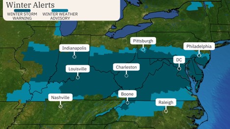
Winter Storm Blair has prompted winter storm warnings from the Ohio Valley to the mid-Atlantic. Snow and ice will snarl travel and cause delays and closures in these regions. Kansas City saw its heaviest snowstorm in more than 30 years on Sunday.
Kansas City picked up 11inches, making it the heaviest snowstorm there since February 1993. Topeka, Kansas, saw its fourth-largest two-day snowfall with a total of 14.1inches. The top storm total is 18 inches at three locations in northeast Kansas.
Winter storm warnings for snow and/or ice stretch from the mid-Mississippi and Ohio valleys to the mid-Atlantic. Those warnings include Baltimore, Cincinnati, Indianapolis, Louisville, Kentucky, and Washington, D.C. In all of these areas, travel should be avoided until the storm has passed.
Monday night, wintry weather should eventually taper off from west to east, but leftover snow and ice on the ground could affect travel in some areas Tuesday morning.
We recognize the severe impact that current conditions are having on our customers, and we are committed to restoring service levels as quickly as possible. As a result of these weather issues, the ALG Client Service Team will send daily updates as we monitor the progress and track job level impact.