Tropical Storm Helene Expected to Become a Major Hurricane Ahead of Florida Landfall
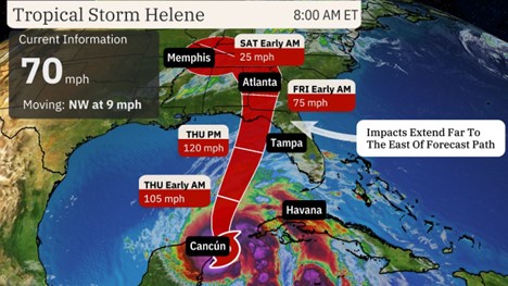
Tropical Storm Helene is intensifying and is forecast to become a large, major hurricane before striking Florida's Gulf Coast on Thursday with life-threatening storm surge, damaging winds, and heavy rain.
Various tropical storm warnings and watches and hurricane watches cover most other parts of Florida northward into South Georgia and southern South Carolina. These alerts mean hurricane, tropical storm and storm surge conditions are either expected (warnings) or possible (watches) in these areas within the next 36 to 48 hours. Interests in the warned areas should implement their hurricane plans and heed any advice from local emergency managers.
Wednesday: Helene's center is making its closest approach to Cancún and Cozumel, bringing high winds, storm surge and heavy rain. Bands of heavy rain and strong winds will also still hammer parts of western Cuba. Helene will eventually enter the southern Gulf of Mexico, intensifying and growing in size. Some high surf and outer rainbands will reach parts of Florida, and tropical moisture intercepting a front could wring out heavy, flooding rain in parts of the Tennessee Valley from Georgia into east Tennessee.
Thursday: Helene is expected to reach its peak intensity in the eastern Gulf and then make a landfall somewhere along the Gulf Coast of Florida as a large, major hurricane Thursday night. While computer forecast models suggest the most likely location for a landfall is in Florida's Big Bend or eastern Panhandle region, remember that hurricane impacts (surge, winds, rain) often happen far from the center, particularly in larger storms.
We recognize the severe impact that current conditions are having on our customers, and we are committed to restoring service levels as quickly as possible. As a result of these weather issues, the ALG Client Service Team will send daily updates as we monitor the progress and track job level impact.